Trip Info
-
Tea House & Tented Camp
-
Included (Guide & Staff)
-
Trekking & Climbing Permits Included
-
6,091
-
Kathmandu
-
Spring & Autumn
-
Kathmandu
-
Professional Climbing Guide
-
Airport Pickup & Drop Included
-
30 Days Before Start
Ramdung Peak Climbing
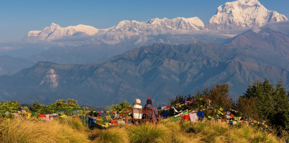
Ramdung Peak stands at 5,925 meters in the remote Rolwaling Valley, one of Nepal’s least-visited high mountain corridors. Unlike the busier trekking peaks near Everest or Annapurna, Ramdung draws climbers who want a genuine wilderness experience without crowds on the trail or fixed ropes from summit to base. The approach alone, winding through forested ridges, stone-walled villages, and the glacially carved upper Rolwaling, makes the journey worth the effort before the real climbing even begins.
The route takes you through Beding and Na, two of the most isolated Sherpa settlements in the Himalayas, where yak herders still follow seasonal grazing patterns unchanged for generations. From Na, the landscape opens into a raw glacial world, with moraines, snowfields, and the dramatic silhouettes of Chugimago and Pachermo flanking the horizon. Ramdung Base Camp sits on a high plateau where the silence is absolute and the views stretch from ridge to ridge without interruption.
The summit push tests your endurance on snow and ice, requiring crampons, rope work, and a confident head for steep terrain. Nepal Holiday Treks designs this 20-day itinerary with built-in acclimatization days and a flexible summit window so your team arrives at the high camp rested rather than rushed. It is a serious objective, but well within reach for trekkers with prior high-altitude experience and a willingness to move slowly and climb smart.
Trip Highlights
- Rolwaling Valley
- Highest trekking peak in Nepal
- Everest or Annapurna, Ramdung
- Remote and less crowded trekking route
- Gradual acclimatization for safety
- Climbing training included
- Glacier walking experience
- Cultural experience in traditional Himalayan villages
Itinerary
You land at Tribhuvan International Airport and transfer to your hotel in Thamel, Kathmandu’s busy traveler district packed with gear shops, bakeries, and narrow alleys. The evening is yours to settle in, get a warm meal, and meet your lead guide for a brief orientation on what the next three weeks will look like. Kathmandu at night has an unmistakable energy, prayer flags strung between rooftops, the smell of incense drifting from nearby temples, the hum of motorbikes on potholed lanes. It is a good idea to use this first evening to check your gear, organize your duffle bags for porters, and get to bed early. The expedition begins properly tomorrow.
This is a full working day even if it does not involve any walking. Your guide team processes your climbing permit for Ramdung Peak and your Gaurishankar Conservation Area entry permit, while you attend a comprehensive briefing covering the route, safety protocols, and daily routines on the mountain. The afternoon is free for any last-minute gear purchases in Thamel, where you can rent or buy quality down layers, trekking poles, gaiters, and mountaineering boots if needed. A team dinner in the evening gives everyone a chance to get acquainted before the road journey the next morning. Sleep well tonight; the drive east tomorrow is long.
You leave Kathmandu in a jeep or private vehicle, heading east along the Araniko Highway before turning onto the Dolalghat road and climbing steadily into the Jiri corridor. The road winds through terraced farmland, sal forest, and small roadside bazaars before reaching Charikot, the gateway town to the Rolwaling Valley. Charikot sits on a broad ridge with sweeping views south across the Tamakoshi river basin, and on a clear morning the Gaurishankar massif appears above the northern horizon like a promise of what is ahead. The town itself is modest, a cluster of tea shops, guesthouses, and a busy local market where vegetables, spices, and live chickens share the same narrow pavement. You check in, rest, and eat well.
A short drive south and then east brings you to the trailhead, where the walking begins in earnest. The path climbs through rhododendron and oak forest, passing terraced potato fields and scattered mani walls before descending into the Rolwaling Khola valley. Simigaon is a compact Sherpa village sitting above the river on a sun-facing slope, its stone houses decorated with painted woodwork and prayer flags strung from bamboo poles. The local monastery here, small but well-maintained, gives you a sense of how deeply Buddhist culture shapes daily life in this part of Nepal. From the village, you get your first clear view up the valley toward the higher peaks, and the scale of what lies ahead starts to feel real. It is an easy, legs-warming day that sets a comfortable pace for the days to come.
The trail drops to the Rolwaling Khola and crosses a suspension bridge before climbing steeply on the opposite bank through dense forest. You pass a few isolated farmsteads and grazing areas where dzopkyos, the Himalayan hybrid of yak and cattle, move slowly through the undergrowth. The gradient eases as you gain the upper valley, and the vegetation shifts from broad-leaved forest to juniper and birch as the air cools noticeably. Dongang is a seasonal settlement used primarily by herders moving their animals between lower and upper pastures; facilities are basic but the views from camp across the valley are open and dramatic. The trail underfoot alternates between stone steps worn smooth by centuries of foot traffic and raw dirt paths edged with wildflowers in season. Arrive, eat, and rest.
This is one of the most visually rewarding days of the approach, and the one where the Rolwaling Valley reveals its full character. The trail follows the river upstream through a narrowing gorge, with vertical rock walls on either side and cascading waterfalls dropping from high tributary streams above. As the valley opens, you enter Beding, the largest permanent village in the upper Rolwaling, sitting in a wide, sunny bowl at over 3,600 meters. Stone houses with flat roofs and carved wooden doorways line the main lane, and the village gompa, active and well-kept, anchors the settlement both physically and spiritually. Local children often congregate around trekkers arriving from the lower trail, curious and unhurried. Beding is where the real mountain world begins, and you feel it in the thin, clean air the moment you arrive.
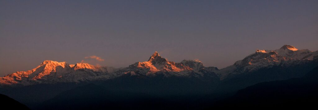
Rest days at altitude are not optional, they are strategic. Today you stay in Beding and allow your body to adapt to the reduced oxygen before climbing higher. A short acclimatization hike of two to three hours on the surrounding hillsides above the village is recommended and easy to arrange with your guide. From the ridge above Beding, you see the valley stretching back toward Charikot and forward toward the glaciated peaks of the upper Rolwaling, with Gaurishankar visible to the west on clear mornings. Back in the village, you can visit the gompa, watch the community’s daily routines, and talk with locals about life here at nearly four kilometers above sea level. A good appetite and the absence of a headache by evening are positive signs that acclimatization is proceeding well.
The trail from Beding to Na is short in distance but significant in altitude, and the landscape transforms completely within a few hours of walking. The valley narrows again above Beding, and the vegetation disappears almost entirely, replaced by bare glacial moraine, scree slopes, and the occasional patch of alpine grass. Na is a summer settlement used by yak herders from Beding between late spring and early autumn, a handful of stone shelters and corrals perched at the edge of the glacier system. The views here are exceptional: Chugimago, Pachermo, and the flanks of Tsho Rolpa’s watershed surround you on three sides, and the glaciers are close enough to hear cracking on warm afternoons. There are very few places in Nepal where you feel this deep inside the mountain world without having yet used technical gear.
A second acclimatization day, this time at Na, consolidates the altitude gain and prepares your body for the higher camp above. Your guide will lead an exploratory hike toward the lower moraine of the Ramdung Glacier, giving you a preview of the terrain you will cross in the coming days and helping your lungs adjust to the thinner air at over 4,000 meters. The light at Na in the morning is particularly striking: sharp, cold, and blue, the kind that makes rock faces glow and glacier ice appear almost turquoise. It is also a practical day for the guide team to assess snow conditions and adjust the route plan if needed. Spend the afternoon resting, eating as much as you can manage, and drinking plenty of fluids.
From Na, the trail pushes directly into glacial terrain. The initial section crosses boulder-strewn moraine before reaching the glacier’s lateral edge, where crampons may be useful on icy patches depending on the season. The route climbs steadily, offering increasingly expansive views back down the Rolwaling Valley and across to the ridge systems that divide Nepal from Tibet. Ramdung Base Camp is established on a relatively flat snowfield or rocky platform below the peak’s southwest flank, a compact, functional site where tents go up fast and the cooking team gets to work as soon as the loads arrive. The surrounding silence at this altitude is something you notice immediately after the bustle of setup, a deep quiet broken only by the wind and the occasional sound of shifting ice. Rest and prepare your summit kit tonight.
Today is methodical and important. Your climbing team runs through rope handling, crampon fitting, ice axe arrest technique, and harness checks, skills that every climber on this expedition needs to have sharp before moving onto steeper terrain. The guides assess the approach route to High Camp and make any necessary adjustments based on current snow conditions and weather patterns. For climbers new to technical mountaineering, this day offers a chance to practice on the lower glacier under close supervision. The physical activity keeps you warm and the routine keeps nerves in check. By evening, everyone knows their role, their gear is packed and ready, and the next morning’s alpine start time is confirmed.
An early departure from Base Camp lets you use the frozen morning snow for better footing on the glacier. The route climbs over a sequence of snowfields and gentle ice ridges, with occasional steeper sections where fixed rope is in place for security. High Camp is established on a sheltered platform or snow bench below the final summit pyramid, giving you the shortest possible summit day without overextending your acclimatization. The views from High Camp are staggering even before the summit, with the Rolwaling peaks arranged in a wide arc and the glaciers below catching the afternoon light in shifting shades of blue and grey. You arrive, melt snow for water, eat a hot meal, and get into your sleeping bag as early as possible. The summit call comes before dawn.
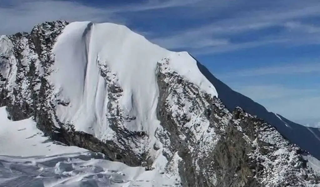
The alarm sounds in the dark, at two or three in the morning depending on conditions, and the team moves out under headlamps on hard-packed snow. The final approach to the summit of Ramdung involves a steep snow and ice slope of approximately 35 to 45 degrees, where crampons bite cleanly and the rope team moves in disciplined rhythm. Near the top, the angle eases slightly before the summit plateau opens and the full panorama unfolds: Gaurishankar to the west, Melungtse and Cho Oyu dominating the north, the Khumbu peaks faint and magnificent on the far eastern horizon. Standing at 5,925 meters on a clear morning with that view is the moment the entire 20-day journey organizes itself around. Descent to High Camp follows the same route, and from there you push on down to Base Camp to celebrate with the full team.
With the summit behind you, the descent through the glacier and moraine back to Na feels entirely different from the climb. The pressure is off, the views are familiar now but somehow warmer in feeling, and the team moves with the easy confidence of people who have done what they came to do. Na’s stone shelters welcome you back with hot tea and a cooked meal that tastes better than almost anything you have eaten in weeks. This is a day to let the adrenaline settle, care for any minor blisters or fatigue, and begin the long mental transition from expedition mode back to the trail. The Rolwaling Valley below looks impossibly green from here compared to the glacial world you have spent the last several days in.
The return through the valley follows the same trail in reverse, but descending always shows you a different version of the landscape than ascending did. Detail you missed on the way up, a carved mani stone beside the trail, the way morning light hits a waterfall across the valley, a cluster of medicinal herbs growing in a crack in the rock, becomes visible when you are not focused on breathing and pace. Beding receives you warmly, and the change in air density at this altitude compared to High Camp is noticeable and welcome. The village teahouses are basic but reliable; hot soup, rice, and dal are always available, and the local chang (barley beer) is sometimes offered to celebration-worthy guests. Rest well tonight.
The trail drops steadily out of the upper Rolwaling, and within a few hours the landscape shifts back from stone and ice to forest and farmland. You pass through the same rhododendron groves you walked through early in the expedition, though the experience of them is entirely different now: your legs are stronger, your lungs are efficient, and you move through the trees with a relaxed ease that the first days never offered. Simigaon appears on its sun-facing slope exactly as you left it, unhurried and quiet. The gompa above the village and the sound of prayer bells in the late afternoon give the descent a fitting, reflective quality. This is the last true mountain night of the expedition.
A jeep meets the team at or near the trailhead below Simigaon for the bumpy road journey back to Charikot. The drive retraces the route through the Tamakoshi valley, past terraced fields and roadside villages, and arrives in Charikot by mid to late afternoon. After days of walking on stone trails and sleeping in tents or basic lodge rooms, the relative comfort of a guesthouse bed and a restaurant meal in Charikot feels like genuine luxury. This is also a good evening to review the expedition photos, take care of any laundry, and give your boots and gear a proper clean before the final drive to Kathmandu tomorrow.
The final road journey returns west along the winding highway to Kathmandu, a route that takes most of the day by jeep. By the time the Kathmandu Valley comes into view from the ridge at Dhulikhel and the city’s sprawl fills the horizon, the contrast between where you have been and where you are returning to is sharp and vivid. Nepal Holiday Treks arranges your hotel transfer and a celebratory team dinner in the city, a chance to share stories with your guides and fellow climbers before everyone disperses. Kathmandu after three weeks in the Rolwaling feels loud, colorful, and alive in a way it probably did not when you first arrived. The noise is welcome now.
A free day in Kathmandu to do with as you please. Some climbers head straight to Thamel for shopping, picking up Thangka paintings, hand-knitted wool goods, or Himalayan tea to take home. Others use the day for a visit to Pashupatinath temple on the banks of the Bagmati river, where the rituals of daily Hindu life play out in plain sight, or to Boudhanath Stupa, where pilgrims circumambulate the great white dome all day long in an unhurried procession. Your guide is available for any last questions or logistical help, including baggage storage, domestic connections, or trekking advice for future trips. The day is yours.
Your airport transfer is arranged based on your confirmed flight time, typically a couple of hours before departure to allow for international check-in. The drive from Thamel to the airport takes twenty to thirty minutes depending on traffic, and the Kathmandu roads are reliably busy at almost any hour. You board your flight carrying not just your duffle bag but the particular calm that follows a serious mountain objective completed well. Ramdung Peak is not a name that appears on most top-ten lists, and that is entirely the point. You went somewhere few people go, climbed a real peak by a real route, and returned with a story that does not need any embellishment.
Includes/Excludes
Cost Includes
- Airport pickup & drop
- Professional climbing guide
- climbing permit
- Trekking permits
- Accommodation during the trek
- Tented camp at Base Camp
- All meals during the trek
- Climbing training
- Safety equipment
- First aid support
- Support staff
Cost Excludes
- International airfare
- Personal climbing gear
- Travel insurance
- Personal expenses
- Tips for guide & porter
- Extra accommodation
- Emergency rescue
FAQs
Yes, prior high-altitude trekking experience and basic mountaineering skills, including crampon use and rope handling, are strongly recommended. Complete beginners will find the technical sections above High Camp difficult and potentially unsafe.
October to November and April to May are the two optimal climbing windows, offering stable weather and clear summit conditions. Monsoon season (June to September) brings heavy snowfall and high avalanche risk, making the route impractical.
You need a Nepal Mountaineering Association (NMA) climbing permit for Ramdung Peak and a Gaurishankar Conservation Area entry permit. Nepal Holiday Treks handles all permit applications as part of the expedition package.
The Rolwaling approach is moderately to highly demanding, involving multi-day trekking on rough trails with significant daily elevation gain. Good cardiovascular fitness and several months of dedicated preparation before the trip are important.
The gradual altitude gain through the valley provides a natural and well-paced acclimatisation profile. If you are particularly altitude-sensitive, a short acclimatisation trek in the Langtang or Everest foothills before the expedition can be a useful addition.