
Trip Info
- Tea House & Tented Camp
- Included (Guide & Staff)
- Trekking & Climbing Permits Included
- 6,091
- Kathmandu
- Spring & Autumn
- Kathmandu
- Professional Climbing Guide
- Airport Pickup & Drop Included
- 30 Days Before Start
Pisang Peak Climbing 12 days
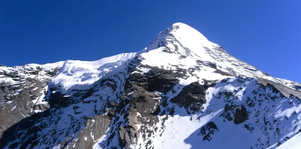
Pisang Peak stands at 6,091 meters in the Manang district of Nepal, tucked inside the Annapurna Conservation Area. It is one of the most rewarding trekking peaks in the country for climbers who want a genuine high-altitude summit without the technical demands of the bigger 8,000-meter giants. The approach winds through some of the most visually striking terrain in the Himalayas, and the summit itself rewards you with a panorama that few places on earth can match.
The route takes you through the Marsyangdi River valley, past medieval stone villages, ancient Buddhist monasteries, and juniper forests dusted in snow. You walk beneath the north face of Annapurna II, cross open meadows where yak herds graze, and sleep under skies that go completely dark and star-filled at high camp. Nepal Holiday Treks designs this itinerary with a careful acclimatization day built in, which makes a real difference at these elevations.
By the time you return to Kathmandu, you carry more than just a summit memory. You carry the texture of those days: the crunch of crampons on ice before dawn, the silence above 5,000 meters, and the slow descent back through a landscape that feels ancient and alive at the same time.
Trip Highlights
- Manang district of Nepal
- Highest trekking peak in Nepal
- Marsyangdi River valley, medieval stone villages, Buddhist monasteries
- Remote and less crowded trekking route
- Gradual acclimatization for safety
- Climbing training included
- Glacier walking experience
- Cultural experience in traditional Himalayan villages
Itinerary
Your journey to Pisang Peak begins the moment you step out of Tribhuvan International Airport into the warm, layered chaos of Kathmandu. The city greets you with the smell of incense, the hum of motorbikes, and narrow streets that somehow accommodate everything at once. After check-in at your hotel in Thamel or a similar area, the afternoon is yours to wander the nearby bazaars or simply rest. If time allows, a short walk to Thamel’s bookshops and gear stores gives you a sense of the climbing culture that pulses through this city. In the evening, your guide team briefs you on the full itinerary, reviews your gear, and answers any questions you have about the days ahead. This is also when paperwork, permits, and final logistics are confirmed. Sleep well tonight because the real journey starts early tomorrow.
The drive from Kathmandu to Chame is a long one, but the scenery keeps the hours from feeling wasted. You leave the city behind and move through the Prithvi Highway, following the Trishuli River west before turning north into the Marsyangdi valley. The landscape shifts progressively, from subtropical rice terraces and banana groves in the lower hills to pine-covered ridges and sharper peaks as you gain elevation. You pass through Besisahar, the traditional start of the Annapurna Circuit, then continue on rougher road through Jagat and Tal before reaching Chame, the administrative headquarters of Manang district. Chame itself is a small but busy mountain town with teahouses, a few shops, and a police checkpoint where trekking permits are verified. The Annapurna range begins to show itself in glimpses through the treeline. This is where the mountain world properly begins.
The trail out of Chame follows the Marsyangdi River through a deep, narrow gorge where pine forests press in from both sides and the sound of rushing water never quite leaves you. You cross wooden bridges, walk along carved cliff paths, and pass the dramatic curve of a natural rock amphitheater near Bhratang where apple orchards grow in unexpected abundance. As the valley opens up, the scale of the Annapurna massif becomes clear and overwhelming. Annapurna II (7,937m) and Annapurna IV (7,525m) dominate the southern wall of the valley with a presence that stops you mid-step. The trail splits at Lower Pisang, and the upper route climbs steeply through a ridge that delivers views across the entire Marsyangdi valley and the Pisang Peak massif ahead. Upper Pisang itself sits on an exposed ridge above the valley floor, surrounded by mani stones and prayer flags that snap in the constant wind. The old village has a gompa worth visiting before dinner, where butter lamps burn in the dim stone interior.
Acclimatization days are not rest days in the passive sense. You spend this one exploring the ridges above Upper Pisang, which already sit well above the valley and offer an unobstructed view of Pisang Peak’s south face and the long glaciated ridgeline you will follow in the days ahead. A walk to the local monastery above the village takes about an hour and reveals hand-painted murals, a collection of thangka paintings, and a view that stretches east toward Manang and beyond. The air here is noticeably thinner than Chame, and the body uses this day to build more red blood cells and adjust to the reduced oxygen. You might feel a mild headache or fatigue in the morning, which is normal and usually passes by afternoon. Nepal Holiday Treks recommends using this day to check your crampons and harness fit before the higher camps. The village itself is quiet and traditional, a good place to observe the local way of life without rushing.
Leaving Upper Pisang, the trail climbs steadily northeast away from the valley, leaving behind the last permanent settlements and the familiar sounds of livestock and children. The path crosses open grasslands and rocky moraines, passing small glacial lakes that reflect the peaks above them with startling clarity. Pisang Peak itself grows larger and more defined with every hour of walking, its summit pyramid and the ridge leading to it now clearly visible. Base camp sits on a broad, relatively flat moraine terrace with good wind protection on two sides and a direct line of sight to the high camp route above. Around camp, the ground is a mix of grey rock, patches of frost, and occasional tufts of hardy alpine grass. The silence up here is a different quality of silence than anything below, total and physical. Your guide team sets up tents, reviews the summit plan in detail, and the evening sky turns extraordinary shades of pink and orange before full darkness.
This is the day the climbing begins in earnest. The route from base camp to high camp gains roughly a thousand meters of elevation, moving through loose rock lower down before transitioning to steeper snow and ice higher up. You clip into the fixed rope sections where the terrain demands it, and your guide walks you through crampon technique and ice axe arrest positions if you need a refresher. High camp is a small, wind-sheltered ledge hacked from the slope, large enough for a few tents and nothing more. From here you look directly across to the Gangapurna glacier and the frozen face of Annapurna III. The afternoon clouds that typically build over the valley do not reach this height, and the views are panoramic and completely unobstructed in clear conditions. You eat a high-calorie dinner early, check your gear one final time, and try to sleep by seven or eight in the evening. The alarm will go off well before midnight.
The alarm breaks the silence at two or three in the morning. You pull on every layer you brought, check your harness and crampons by headlamp, and step out into the cold. The pre-dawn sky above 5,400 meters is genuinely startling, dense with stars and completely clear in good conditions. The climb to the summit moves along a steep snow ridge, with fixed ropes on the most exposed sections and a short ice wall near the top that requires careful front-pointing. The summit of Pisang Peak at 6,091 meters delivers one of the most complete panoramas in the Annapurna region: Annapurna I, II, III, and IV arranged across the southern horizon, the Chulu peaks to the east, and the Tibetan plateau fading north into brown distance. You spend a few minutes at the top, photograph the moment, and begin the descent. The return to base camp takes most of the morning. By early afternoon you are back at base camp, tired and quietly satisfied in a way that is hard to explain to anyone who has not stood on a summit at dawn.
Mountain weather is not predictable, and this day exists precisely because of that fact. If the summit was completed on Day 7, this day becomes a genuine rest day at base camp or an early move toward lower elevations. If weather delayed the summit attempt, today becomes the window. Cloud, wind, and poor visibility at high altitude can shift quickly in either direction, and experienced guides read the signs carefully before making any call. Nepal Holiday Treks builds this contingency day into the itinerary so that no climber is pushed onto the mountain in unsafe conditions simply because of a schedule. Spending an extra night at base camp, watching the weather clear from the west, is itself an experience. The mountains are never more vivid than after a storm passes.
The descent from base camp back toward the valley feels fast after the slow, careful climb of the past few days. The trail drops through the moraine and grassland zones, and the oxygen-rich air below 3,500 meters feels almost thick in comparison to what you have been breathing. Dhikur Pokhari is a small Gurung village on the western side of the Annapurna Circuit route, sitting beside a calm lake that reflects the surrounding peaks in the early morning light. The village has a handful of teahouses and a quiet, end-of-the-day character that suits the mood perfectly. The walk passes through rhododendron and oak forests that you mostly ignored on the way up, and now they look lush and inviting in comparison to the bare rock above. You arrive with tired legs and a good appetite, and the evening is slow and comfortable.
The road from Dhikur Pokhari descends through the lower Marsyangdi valley, passing terraced farmland, water-powered grain mills, and villages where the mountain life gradually gives way to the rhythms of the lowland Terai. The drive is bumpy on sections of unsealed road, but the scenery compensates fully. Besisahar is the main town of the Lamjung district, a proper road-connected town with markets, restaurants, and a noticeably warmer temperature than anything you have experienced in the past week. It is a good place to eat something that is not expedition ration food, pick up a cold drink, and sit with your team to talk through the climb. The contrast between Besisahar and the high camp you occupied just two nights ago is striking and a little surreal.
The final road journey follows the Prithvi Highway east along the Trishuli River before climbing over the low ridges and dropping into the Kathmandu Valley. The drive takes most of the day, and the city appears gradually through the haze as you descend toward the valley rim. After more than a week in the mountains, Kathmandu feels loud and warm and wonderfully full of food options. The evening is free for a team dinner, a walk through Thamel, or simply the comfort of a proper bed. This is a good time to share photos, buy souvenirs, and acknowledge what the last twelve days actually involved.
Depending on your flight time, the morning may allow for a final walk around Kathmandu, a visit to Boudhanath Stupa, or a leisurely breakfast in Thamel. Your guide or the Nepal Holiday Treks team arranges airport transfer and ensures you reach Tribhuvan International Airport with enough time for check-in and departure formalities. You leave Nepal having stood on a 6,000-meter summit, having walked through some of the most dramatic terrain on the planet, and carrying a set of memories that will stay specific and vivid for a long time.
Includes/Excludes
Cost Includes
- Airport pickup & drop
- Professional climbing guide
- climbing permit
- Trekking permits
- Accommodation during the trek
- Tented camp at Base Camp
- All meals during the trek
- Climbing training
- Safety equipment
- First aid support
- Support staff
Cost Excludes
- International airfare
- Personal climbing gear
- Travel insurance
- Personal expenses
- Tips for guide & porter
- Extra accommodation
- Emergency rescue
FAQs
Yes, some prior high-altitude trekking experience is strongly recommended before this climb. Basic ice axe and crampon skills are essential, and you should be comfortable walking on steep snow slopes.
Spring (March to May) and autumn (September to November) offer the most stable weather and clear summit windows. Winter and monsoon seasons bring conditions that make the climb significantly harder and less safe.
You need a trekking peak climbing permit issued by the Nepal Mountaineering Association (NMA), along with an Annapurna Conservation Area Permit (ACAP) and a TIMS card. Your guide or trekking company handles the permit process before departure.
You should be able to hike consistently for five to six hours on consecutive days, including on rocky and steep terrain. Regular cardio training for at least two to three months before the trip makes a noticeable difference on summit day.
Yes, comprehensive travel insurance that covers high-altitude trekking and helicopter evacuation up to 6,500 meters is essential, not optional. Most reputable operators, including Nepal Holiday Treks, require proof of valid insurance before the trip begins.