Trip Info
-
Tea House & Tented Camp
-
Included (Guide & Staff)
-
Trekking & Climbing Permits Included
-
6,187m
-
Kathmandu
-
Spring & Autumn
-
Kathmandu
-
Professional Climbing Guide
-
Airport Pickup & Drop Included
-
30 Days Before Start
Pharchamo Peak climbing 18 days
Pharchamo Peak (6,187m) sits at the heart of the Rolwaling Valley, one of Nepal’s least-traveled high-altitude corridors. This 18-day expedition takes you through dense rhododendron forests, ancient Sherpa villages, and glaciated terrain that builds steadily toward one of the most rewarding technical summits in the country. Unlike the crowded Everest or Annapurna circuits, Rolwaling feels genuinely remote, and that solitude is part of what makes this climb so compelling.
The route passes through Charikot, Simigaon, and Na village before reaching Tsho Rolpa, a glacial lake ringed by peaks that reflect off its turquoise surface on clear mornings. From base camp, you cross the Tesi Lapcha Pass (5,755m), a high glacial crossing that connects Rolwaling to the Khumbu, before the final push to Pharchamo’s summit. Nepal Holiday Treks operates this route with experienced high-altitude guides who know the Rolwaling terrain across seasons.
Pharchamo is considered a trekking peak, but it demands genuine mountaineering skills, including crampon and ice axe technique, rope management, and the mental steadiness that high-altitude climbing requires. The reward is proportional to that effort: a 360-degree panorama from the summit that takes in Everest, Cho Oyu, Gauri Shankar, and the full sweep of the Rolwaling Himal. This expedition suits climbers who want real altitude, real challenge, and real wilderness without the infrastructure crowds of more popular Himalayan routes.
Trip Highlights
- Rolwaling Valley range
- Highest trekking peak in Nepal
- Charikot, Simigaon, and Na village
- Remote and less crowded trekking route
- Gradual acclimatization for safety
- Climbing training included
- Glacier walking experience
- Cultural experience in traditional Himalayan villages
Itinerary
Your expedition begins the moment you land in Kathmandu and step into the organized chaos of Tribhuvan International Airport. The city greets you with the smell of incense, the hum of motorbikes threading through narrow lanes, and the distant sight of temple spires rising above the rooftops of Thamel. After check-in at your hotel, the afternoon is yours to wander Thamel’s packed alleys, grab last-minute gear, or simply let the altitude and time zone adjustment settle in. In the evening, your lead guide sits with you for a full briefing covering the route, permits, weather patterns, and what to expect on the mountain. It is worth paying close attention here since the logistics of a Rolwaling expedition are more involved than a standard Himalayan trek.
The drive east from Kathmandu on the Araniko Highway begins with the gradual exit from the valley’s urban sprawl and opens into a landscape of terraced hillsides, roadside tea houses, and occasional river crossings over suspension bridges painted orange and blue. Charikot is a small market town perched above the Tamakoshi River gorge, and arriving there feels like stepping into a quieter Nepal, one where mornings smell of woodsmoke and evenings are lit by a single string of bulbs over a tea house porch. The drive itself takes around six to seven hours depending on road conditions, which can be unpredictable after monsoon season. You will overnight here in a basic but clean guesthouse, and most climbers find the relative stillness a welcome contrast to Kathmandu. Use the evening to recheck your pack and get to bed early since Day 3 starts the physical work.
The road beyond Charikot deteriorates quickly into a rough jeep track that clings to the side of steep ridges above the Tama Koshi valley. It is bumpy, occasionally nerve-wracking, and absolutely worth it because the views that open up around each bend are extraordinary. Simigaon is a Tamang village at around 2,000 meters, surrounded by fields of millet and barley and overlooked by a small gompa where prayer flags snap in the afternoon wind. Most teams spend the first real walking hours here stretching their legs with a short village walk before dinner. The community here has lived in the Rolwaling shadow for generations and their familiarity with trekkers and climbers is genuine rather than transactional. You can hear the Rolwaling Khola river far below in the gorge on quiet evenings.
Today is your first full day on foot, and the trail wastes no time proving that Rolwaling is serious terrain. The path climbs steeply through old-growth forest where rhododendrons and oak trees form a dense canopy overhead and moss carpets the rocks underfoot. You cross several small suspension bridges over side streams that feed the main river, and by mid-morning the valley begins to narrow into something that feels genuinely wild. Dongang is a small seasonal settlement used mainly by herders, and the view from its clearing back down the valley is worth the effort it took to reach it. Your camping crew will have tents set up and tea waiting, which after a steep day of ascent feels like a legitimate luxury. The sky in Rolwaling is noticeably darker and fuller of stars than almost anywhere else in Nepal.
The trail continues to follow the Rolwaling Khola upstream, crossing and recrossing the river on log bridges and stepping stones worn smooth by decades of yak traffic. Beding is the first major settlement in the valley, a proper Sherpa village with stone houses, a monastery that dates back several centuries, and a school whose children often run out to watch passing expeditions with spectacular indifference. The monastery at Beding is one of the hidden cultural gems of the entire trek and worth at least thirty minutes of quiet exploration. The paintings inside are vivid and old, depicting wrathful deities and protective spirits of the mountain pantheon. Most teams rest here briefly before continuing to their campsite just beyond the village where the air begins to carry that particular high-altitude dryness.
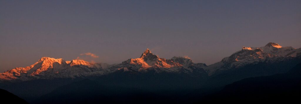
Na is the last permanently inhabited settlement in the Rolwaling Valley, and everything beyond it belongs to the mountain. The walk from Beding is relatively short but the landscape transformation is dramatic: the tree line drops away, yak pastures open up on either side of the trail, and the peaks that have been hinting at themselves for the past two days now reveal themselves fully. Gauri Shankar (7,134m) dominates the southern skyline in a way that is genuinely hard to take your eyes off. Na itself is a cluster of stone herders’ huts used seasonally, and in autumn the community is alive with yak herders preparing their animals before the winter migration. Nepal Holiday Treks typically uses Na as a key acclimatization stop, allowing climbers an extra rest day to let the body adjust before pushing higher into the Rolwaling cirque.
Rest days at Na are rarely passive. Most climbers spend the morning on a short acclimatization hike up the ridgeline above the village, which rewards the effort with a direct view of Tsho Rolpa glacier and the wall of peaks that encircle the upper valley. The body needs this day more than most people expect, and anyone who has trekked above 4,000 meters before will recognize the value of moving slowly and eating well rather than pushing forward. In the afternoon, the guides typically review crampon technique, harness fitting, and ice axe self-arrest practice on a gentle snow slope nearby. The sky clears most afternoons here and the light on the glacier turns the ice a shade of blue that you will not forget easily. Sleep high, walk high, then sleep lower; the old rule holds here as well as anywhere.
Tsho Rolpa is one of the largest glacial lakes in Nepal and one of the most visually striking places on the entire expedition. The trail from Na follows the lateral moraine of the glacier before dropping to the lake shore, where turquoise water stretches out beneath a wall of ice and rock that rises almost vertically to the ridge above. The scale of Tsho Rolpa does not fully register until you are standing at its edge and realize the far shore is more than three kilometers away. There is a monitoring station here run by the government due to the lake’s flood risk potential, which adds an unexpectedly human element to an otherwise raw landscape. Camping near Tsho Rolpa is cold even in October, but the evening light on the ice cliffs across the water more than compensates. Keep your water bottles inside your sleeping bag overnight.
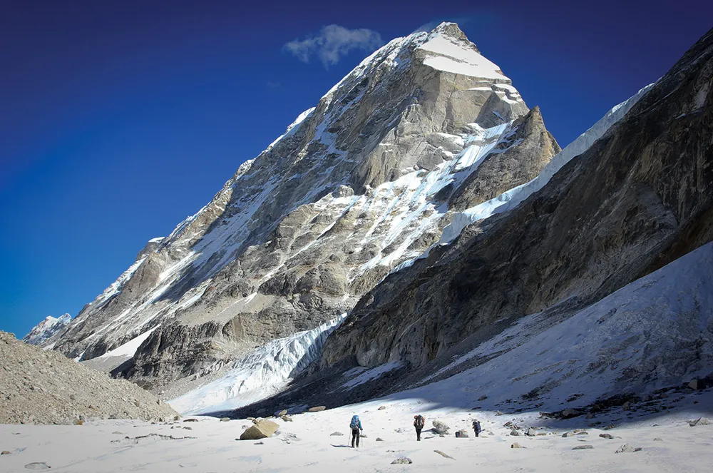
The approach to base camp involves picking a careful path across the terminal moraine of the Ripimo Shar Glacier, where loose rock and occasional ice patches demand full attention underfoot. This is where the expedition shifts gear: you are now in proper mountaineering terrain, and the casual trekking rhythm of the past week changes into something more deliberate. Base camp sits on a relatively flat section of moraine with a direct view of Pharchamo’s south face and the Tesi Lapcha headwall. Your high-altitude team will have the camp organized efficiently, with separate tents for sleeping, cooking, and gear storage. The afternoon is spent organizing climbing equipment, sorting rope systems, and having a detailed route briefing from your lead climbing guide. Weather permitting, you can see the entire summit route from camp.
Today tests both your fitness and your technical skills in a controlled setting. The team moves up to high camp, spending several hours on the glacier practicing rope travel, crevasse navigation, and crampon technique on steeper ground than the acclimatization hike at Na provided. High camp is a small exposed platform carved into the snow at around 5,600 meters where the wind tends to pick up sharply in the afternoons. You sleep here if conditions allow, or descend to base camp for a warmer night and return tomorrow. Either way, this is the rotation that matters most for summit preparation. The view from high camp toward Everest and Cho Oyu on the northern horizon is extraordinary and well worth the discomfort of sitting in crampons on a windy ledge.
A recovery day at base camp before the summit push is not optional; it is part of the strategy. The body performs better on summit day after a genuine rest than after a day of half-effort activity, and most experienced mountaineers treat this rule seriously. Your guide team uses this time to review the summit plan in full, including departure time (typically between midnight and 2 a.m.), rope team order, turnaround time, and communication protocol. Climbers check and double-check their personal gear: boot fit, crampon attachment, harness buckles, headlamp batteries, glove layers, and summit snacks. It is also worth writing down or mentally rehearsing the turnaround time so that summit fever, which is real and surprisingly persuasive at altitude, does not override good judgment when you are close to the top.
You leave base camp in the dark, headlamps cutting narrow paths through the pre-dawn cold, crampons biting into the hard glacier ice with a satisfying crunch. The route climbs the south face of Pharchamo through a mix of moderate and steeper ice, with fixed ropes on the technical sections above the col. The upper mountain narrows into a final ridge that requires careful footing and focus, and then the summit opens up. Standing on top of Pharchamo, you can see Everest, Lhotse, Cho Oyu, Gauri Shankar, and the full Rolwaling cirque laid out in every direction in a panorama that simply cannot be described accurately in advance. The descent requires the same focus as the climb, and the team moves carefully back to base camp where hot drinks and a proper meal are waiting. This is the day the entire expedition has been pointing toward.
This is one of the most demanding single days of the entire expedition. The Tesi Lapcha Pass is a 5,755-meter glacial crossing that connects the Rolwaling Valley to the Khumbu, and it involves glacier travel, a steep fixed-rope headwall, and a long descent on the far side to the Sherpa village of Thame. The crossing itself is exposed and requires full glacier equipment, and the headwall section demands confident movement on fixed lines. But the crossing also delivers one of the great moments of Himalayan travel: the instant you reach the pass and the entire Khumbu Himal unfolds before you, with Everest visible in the distance, it feels genuinely earned. Thame is a traditional Khumbu village with well-run teahouses and the welcome luxury of a real bed after days on the moraine.
The trail from Thame down to Namche follows the Bhote Koshi River valley, dropping steadily through juniper scrub and past mani walls inscribed with thousands of prayers. Namche Bazaar, perched in its horseshoe-shaped bowl above the river confluence, arrives suddenly around a corner in the trail, as it always does, with its bakeries, gear shops, and crowded trekking lodges. After the strict minimalism of the Rolwaling camp routine, Namche feels overwhelming in the best possible way. A hot shower, a real espresso, and a seat by a warm stove are genuinely restorative. Your legs have done serious work over the past two weeks and this descent, while straightforward, is a reminder of just how much elevation you have accumulated.
The classic Khumbu descent from Namche to Lukla is well-trodden and busy with porter traffic, yak trains, and returning trekkers. The trail drops through Monjo and Phakding before the final climb to Lukla’s main street, which buzzes with the particular energy of people either beginning or finishing a Himalayan adventure. This day has a satisfying symmetry to it: you are physically descending, the hard work is behind you, and the body begins the gradual process of returning to normal oxygen levels with noticeable effect on appetite and energy. Lukla is loud, crowded, and full of celebration dinners, and after eighteen days in the mountains, all of that feels entirely appropriate.
The morning flight from Lukla’s famously short runway is an experience in itself, with the strip ending at a cliff edge and the aircraft banking sharply into the valley below before climbing toward Kathmandu. Weather delays at Lukla are common and always worth building a buffer day for, which this itinerary already accounts for. Once back in Kathmandu, the contrast with where you were two days ago is striking. Nepal Holiday Treks arranges your transfer to your hotel and the afternoon is open for a celebration dinner, souvenir shopping in Thamel, or simply sitting still and doing nothing at all, which after an 18-day expedition is actually quite difficult to do.
This day exists for two good reasons: flight delays from Lukla are unpredictable, and Kathmandu genuinely rewards a slow morning after a serious expedition. If the flight came in on schedule yesterday, today is yours entirely. Pashupatinath Temple on the banks of the Bagmati River is worth a visit, as is the Boudhanath Stupa, whose white dome and watchful eyes preside over a neighborhood of Tibetan monasteries and butter lamp vendors. If you are the kind of person who processes experiences through journaling or photography organization, a quiet afternoon in a Thamel cafe is a good use of this time. Many climbers also use this day to book ahead for their next Nepal trip, which is a pattern worth noting.
Your transfer to the airport depends on your flight time, and your guide or the Nepal Holiday Treks team will confirm logistics the night before. Kathmandu in the early morning, before the traffic builds and the city fully wakes, has a quality of light and stillness that is its own kind of farewell. Whatever you carry home from this trip, whether it is a summit photograph, a recalibrated sense of what your body can do, or simply the memory of that pre-dawn start on a glacier at 5,100 meters, it will stay with you longer than you expect.
Includes/Excludes
Cost Includes
- Airport pickup & drop
- Professional climbing guide
- climbing permit
- Trekking permits
- Accommodation during the trek
- Tented camp at Base Camp
- All meals during the trek
- Climbing training
- Safety equipment
- First aid support
- Support staff
Cost Excludes
- International airfare
- Personal climbing gear
- Travel insurance
- Personal expenses
- Tips for guide & porter
- Extra accommodation
- Emergency rescue
FAQs
Yes, prior experience with crampons, ice axe, and fixed ropes is necessary. Pharchamo is a technical trekking peak, and climbers without basic mountaineering skills will struggle on the summit push. A prior course or guided climb on a lower technical peak is strongly recommended before attempting this route.
October to November is the most reliable window, with stable skies and firm snow conditions on the upper mountain. Spring (April to May) is also viable, though lingering snowfall can make the Tesi Lapcha crossing more demanding than in autumn.
You need a Pharchamo Peak Climbing Permit from the Nepal Mountaineering Association, a Gaurishankar Conservation Area Permit, and a TIMS card. Your operator handles all of these on your behalf before departure.
The walk through Rolwaling is long and involves several consecutive days of steep ascent and descent on narrow trails. Strong cardiorespiratory fitness built through consistent uphill training over at least three months will serve you well here.
Not without guidance. The pass involves glacier travel, crevasse risk, and a steep headwall that requires fixed rope use. Every climber on this route crosses it with a guide and full glacier equipment, regardless of individual experience level.


