Trip Info
-
Tea House & Tented Camp
-
Included (Guide & Staff)
-
Trekking & Climbing Permits Included
-
6,249 meters
-
Kathmandu
-
Spring & Autumn
-
Kathmandu
-
Professional Climbing Guide
-
Airport Pickup & Drop Included
-
30 Days Before Start
Larkya Peak Climbing – 21 Days
Larkya Peak stands at 6,249 meters in the remote Manaslu region, and reaching its summit means earning every single step. The approach follows the wild Budhi Gandaki valley, where terraced farmland gives way to dense rhododendron forests, then bare granite ridges dusted with permanent snow. By the time you reach base camp, the scale of the mountain comes into full view, its south face rising steeply above a fractured glacier.
The technical sections require crampons, fixed ropes, and a genuine respect for high-altitude conditions. You navigate crevasse fields, negotiate exposed ridges, and push through the pre-dawn cold on summit day when the sky above the Himalayas shifts from black to a sharp, burning orange. The reward is a summit panorama that stretches across Manaslu, Himalchuli, and the glaciated peaks of the Tibetan border.
Nepal Holiday Treks designs this itinerary with acclimatization built in properly, not squeezed. The descent loops back through Samagaon and crosses the legendary Larkya La pass before dropping into the Annapurna region at Dharapani. It is a complete Himalayan experience from culture to summit, tied together in one continuous journey.
Trip Highlights
- Manaslu region, Budhi Gandaki valley
- Highest trekking peak in Nepal
- Remote and less crowded trekking route
- Gradual acclimatization for safety
- Climbing training included
- Glacier walking experience
- Cultural experience in traditional Himalayan villages
Itinerary
You land at Tribhuvan International Airport and are transferred to your hotel in Thamel, the energetic hub of Kathmandu where prayer flags hang across narrow alleys and the smell of incense drifts out of every second doorway. The afternoon is yours to rest and recover from the flight, but if you are still alert, a short walk to Boudhanath Stupa rewards you with one of the most quietly powerful sights in South Asia. The massive dome, ringed by butter lamp shrines and monks in maroon robes making clockwise circuits, puts you immediately in the right headspace for what is ahead. Your climbing team completes final permit checks, goes through equipment verification, and confirms the briefing schedule for the following morning. This is also the day to pick up any last-minute gear from the shops along Thamel Marg if your kit needs topping up.
The road out of Kathmandu climbs quickly through the Prithvi Highway before peeling north into the Budhi Gandaki corridor. You pass through Dhading Besi and watch the landscape shift from roadside shops and rice paddies to steep river gorges where the road clings to the hillside. The last stretch into Soti Khola is rough, and the jeep shakes through potholes as the valley narrows and the river turns a cold glacial grey-green below. Soti Khola itself is a small cluster of tea houses perched on a riverside flat, surrounded by subtropical forest. Hornbills and laughing thrushes are audible even from the tea house veranda. This overnight stop is your official gateway into the Manaslu restricted zone, and the permits are checked here before the trek begins tomorrow morning.
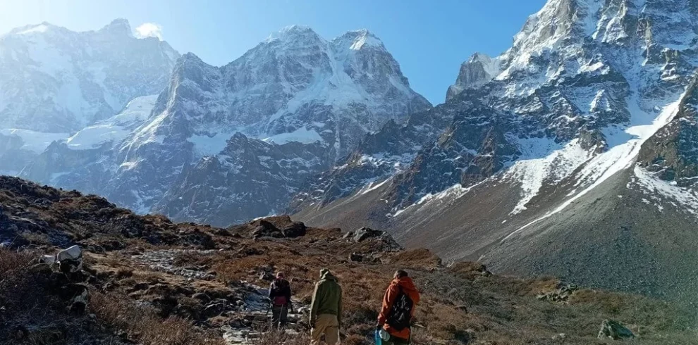
The trail follows the east bank of the Budhi Gandaki through subtropical forest thick with banana plants, ferns, and the occasional burst of wild ginger. You cross several suspension bridges where the river churns loudly below, the cables trembling faintly with each gust of valley wind. Small villages appear along the route, their stone houses terraced into the hillside, with chillies laid out to dry on rooftops and goats picking through the garden walls. The path is rocky and frequently rises and falls without warning, which is typical of the lower Budhi Gandaki valley. By the time Machha Khola comes into sight, the valley has opened enough to reveal a first clean view of distant snow peaks to the north. The village itself sits on a wide gravel bar beside the river, with tea houses serving fresh dal bhat and a few wooden benches outside facing the water.
The route continues its relentless up-and-down pattern through more forested slopes above the river. You pass through Kholabesi and Tatopani, where a small hot spring beside the trail offers a tempting mid-morning soak if time allows. The bridge crossings multiply here, and in a few sections the trail cuts into steep cliff faces where the drop to the river below keeps you focused on every footfall. Jagat is the first significant checkpoint on the Manaslu Circuit, where your restricted area permit is examined by police and recorded in their ledger. The village is compact and well-organised, with a row of tea houses lining the trail, some with solar-powered lights and clean sitting rooms. Porters tend to gather here in the evenings, and the conversations across long wooden tables over mugs of butter tea make for genuinely warm company.
Above Jagat, the valley begins to feel distinctly wilder. The cultivated terraces thin out, replaced by raw granite walls and forest that looks like it has never been cleared. You pass through the Gurung village of Salleri and descend sharply to a long suspension bridge before climbing again to Phillim, a large village with a gompa and prayer mani walls carved with the six-syllable mantra running along the path. The culture shifts noticeably here as you move deeper into the Tibetan-influenced belt. Deng sits on a forested shelf above the river, quieter than Jagat, with fewer trekkers and a simpler set of lodges. The evenings cool down quickly and the stars appear sharp and close above the tree line. This is one of those days where the valley’s mood begins to change from trekking corridor to genuine wilderness.
The trail beyond Deng passes through a narrow gorge section before opening into wider highland meadows. You trek through Rana and Bihi, two small villages where the whitewashed chorten gates mark the entrance and exit of each settlement in the traditional Tibetan manner. Juniper and blue pine begin to replace the subtropical forest, and the air carries a resin scent that is distinct and pleasant at this elevation. Namrung occupies a high ridge with sweeping views north toward Ganesh Himal and east toward the ridgeline that feeds into Manaslu’s satellite peaks. The tea houses here are a step up in comfort compared to the lower valley, with thicker blankets and wood-fired stoves that the owners stoke generously in the evening. The population in Namrung is Nubri Tibetan, and the sound of hand drums and bells from the nearby gompa often carries across the settlement at dusk.
This is the day the mountains announce themselves properly. The trail climbs through the forest above Namrung and eventually breaks out onto an open, high-altitude plain where Manaslu’s north face fills the entire northern horizon. At 8,163 meters, Manaslu is the world’s eighth highest mountain, and seeing it from this angle, unobstructed and enormous, stops most trekkers mid-stride. You pass through Lho village, where a restored monastery sits below the ridge with painted murals and a butter lamp room kept burning day and night. Soma and Shyala follow before the long flat walk into Samagaon, a sizeable Tibetan village that serves as the main hub for both Manaslu Circuit trekkers and climbers heading to Larkya Peak. The lodges are comfortable, the yak cheese is excellent, and the view of Manaslu from the main courtyard is genuinely difficult to leave.
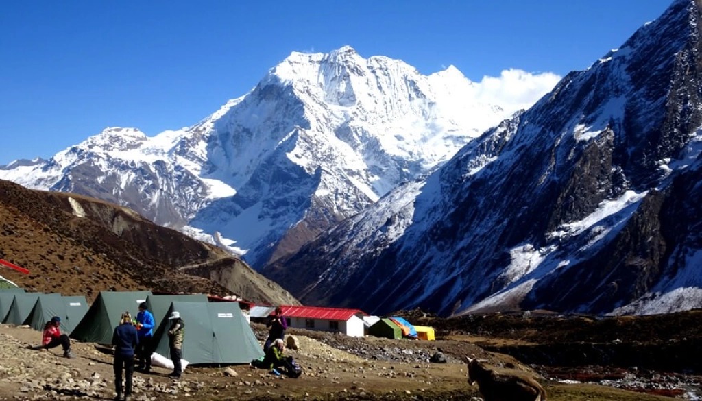
You leave the village trail system behind and cross into serious glacier terrain. The route heads north from Samagaon, crossing a series of glacial moraines and following a faint climbers’ path marked with cairns across boulder fields. The landscape is raw and open, with no trees and no shelter between you and the ice. Larkya Glacier comes fully into view about halfway in, its fractured surface of ice seracs and blue crevasses glinting under the morning sun. Base camp sits on a stable moraine platform with a direct sightline to the south face of Larkya Peak above. Once tents are pitched and the camp is organised, your guide briefs the team on the climbing schedule, identifies the fixed rope lines already in place, and points out the route to Camp 1 on the lower icefall. The silence up here is the kind that takes some adjustment.
The body needs time at this altitude, and this day is used purposefully rather than spent entirely at rest. The morning involves a guided acclimatization hike up the lower glacier to orientate yourself with crampons on ice, practice self-arrest technique, and get comfortable on the fixed ropes in a low-stakes setting. You look up and trace the summit ridge from below, working through the route in your mind while the guide explains each section. The afternoon is genuinely restful: eat, hydrate, adjust layers, and sleep if the body allows. Headaches are common here and not a cause for alarm unless they worsen overnight. The sky above base camp is often brilliantly clear in the morning before afternoon cloud builds up from the south, and the low light across the ice fields in the evening is extraordinary.
Moving up onto the glacier properly, you rope up with your climbing team within the first thirty minutes of departure. The lower icefall requires careful navigation between crevasses, some bridged by aluminium ladders anchored at both ends. Fixed ropes appear above the steeper sections, and you clip in methodically, moving at a slow and sustainable pace. Camp 1 sits on a flattened snow shelf pressed against the ridge wall, just wide enough for a few tents. The view back down the glacier toward base camp and the valley beyond is already impressive, with Manaslu’s summit pyramid visible above the ridgeline to the west. You spend the afternoon brewing tea, eating high-calorie snacks, and trying to sleep early in preparation for the summit push. The wind picks up in the late afternoon and the tent fabric shakes steadily through the night.
The route from Camp 1 steepens immediately, and the glacier gives way to mixed terrain of compressed snow and exposed rock. You gain elevation quickly, crossing a wide snowfield before a final steep section leads to the high camp ledge. At this elevation, every step requires deliberate breathing, and conversation between team members reduces to short, practical exchanges. High camp is perched on a narrow ridge, with a sheer drop visible on the north side and the summit ridge rising sharply above. The tents are staked into the snow with extra anchors given the wind exposure. You eat a warm meal, check your gear one final time, set alarms for the pre-dawn departure, and try to sleep despite the altitude, the cold, and the anticipation. The team leader reviews the weather window and confirms the go or hold decision before lights out.
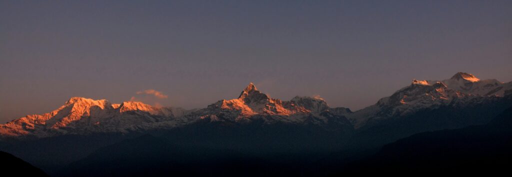
Departure is around midnight or 1 a.m., headlamps cutting through the dark as the team moves slowly up the ridge. The cold at this hour is serious, and breath freezes on jacket collars within minutes. The summit route follows the north ridge, with fixed ropes on the steeper rock and mixed sections. Above 6,000 meters the view opens in every direction, and by the time the first pre-dawn light touches Manaslu to the west, the scale of what you are standing in becomes almost difficult to process. The summit of Larkya Peak at 6,249 meters offers an unobstructed 360-degree panorama across the Manaslu Massif, Himalchuli, Ngadi Chuli, the Tibetan plateau, and the distant white line of peaks along the Annapurna range. Descent is careful and methodical, and by late afternoon the team is back at base camp, exhausted and relieved.
With the summit behind you, the walk back down the moraine to Samagaon feels entirely different than the approach. The body is tired but the tension is gone, and you notice details you missed on the way up: the colour of lichen on the boulders, the way melt-water streams cut bright channels through the moraine debris. Samagaon receives you warmly. The lodge owners recognise climbers coming down from the mountain and there is a quiet understanding in the welcome. Nepal Holiday Treks ensures your team has proper rest, warm food, and time to process the experience before the continuing journey. The evening in Samagaon is one of the most genuinely satisfying of the entire trip, a combination of physical relief, good food, and the knowledge that the mountain was reached and left safely.
The trail east from Samagaon enters an even more Tibetan-feeling landscape. The vegetation is sparse, the wind is persistent, and the sky feels wider and bluer at this elevation. You pass a long row of prayer wheels set into a stone wall that clicks and spins as each trekker pushes them in sequence. Samdo is a small, closely-built village with flat-roofed stone houses arranged around a central lane, and a monastery at the upper edge that dates back several centuries. The monks here occasionally sell yak butter and barley flour from a side room off the main prayer hall. From Samdo you can already see the high ridge of Larkya La to the east, and the route across it is faintly visible as a pale line of footprints in the snow. The overnight here feels remote in the best possible way.
The climb toward Dharmasala is gradual but unrelenting. The trail leaves all vegetation behind within the first hour and crosses a high plateau of rock, ice, and wind-compressed snow. Yak caravans occasionally pass in the opposite direction, their bells audible long before the animals appear around a bend. Dharmasala is the last shelter before the Larkya La crossing, a set of stone and corrugated iron tea houses pressed against a cliff for protection from the wind. The interior is smoky, low-ceilinged, and basic, but the warmth from the stove and the companionship of other trekkers gathered here makes it genuinely hospitable. An early sleep is essential because Larkya La is best crossed in the morning before the afternoon wind picks up and visibility deteriorates. The stars from this elevation are exceptional.
Larkya La at 5,106 meters is one of the most dramatic high passes in Nepal, and the crossing earns its reputation. You leave Dharmasala before first light and ascend through a snowfield that steepens gradually toward the pass. The final approach to the top involves some scrambling over loose rock and ice, and the cairn at the summit is draped in faded prayer flags that snap loudly in the wind. The view from the pass is extraordinary on a clear morning: Manaslu, Cheo Himal, Himlung Himal, and the entire Annapurna massif laid out to the south. The descent to Bimthang is long and requires concentration on the icy upper sections, but the valley opening below gradually softens into pasture and forest. Bimthang itself is a summer yak herding settlement with a spectacular unobstructed view of Manaslu rising directly to the north.
The descent from Bimthang back into lower valley terrain is rapid and welcome. The trail drops through rhododendron and oak forest, with the trees thickening and the air warming noticeably with every hundred meters of descent. You pass through Hampuk and cross a long suspension bridge above a deep gorge before the trail levels out into a wider valley with corn fields and apple orchards. Tilije is a classic Gurung village with stone-paved lanes, carved wooden window frames, and a community water tap where locals gather in the mornings. The sounds of roosters and children playing replace the wind and silence of the high passes, and the sensory shift is remarkable. Sitting on a lodge veranda at Tilije with a cup of tea and a view of forested ridges on three sides marks a genuine transition back to the inhabited world.
The final trail section runs along the valley floor through Thonje and across the junction bridge to Dharapani, where the Annapurna Circuit route merges with your trail. The village is larger and notably more commercial than anything on the Manaslu Circuit side, with mobile signal, ATMs, and a paved road that arrives almost as a surprise after weeks without one. From Dharapani a jeep or local bus follows the Marsyangdi River valley south through Chame and Besisahar, the road dusty and bumpy but mercifully fast after days on foot. Besisahar is the district headquarters of Lamjung and a proper town with restaurants and shops. You overnight here before the final drive to Kathmandu the following morning.
The drive back to Kathmandu follows the highway south through the Terai foothills before swinging east into the Prithvi Highway and back into the Kathmandu Valley. The contrast between the quiet mountain landscapes of the last three weeks and the sudden density of the capital is striking. Traffic thickens, horns multiply, and the city reasserts itself. By the time you reach the hotel in Thamel, a hot shower, a proper bed, and the option of pizza or momos for dinner feels like genuine luxury. The evening is free for personal celebration, quiet reflection, or both. Your climbing certificate, if earned, is issued by Nepal Mountaineering Association and makes a fitting end to the paperwork side of the journey.
A full day in Kathmandu to decompress and explore. The UNESCO World Heritage Sites in the valley are within easy reach and well worth a proper visit if you have not seen them before. Pashupatinath Temple on the Bagmati River is one of the most important Hindu pilgrimage sites in Asia, with cremation ghats, wandering sadhus, and elaborately carved temple towers. Swayambhunath, the hilltop stupa nicknamed the Monkey Temple, gives you a wide panoramic view of the entire Kathmandu Valley from its upper platform. If the afternoon allows, the old city of Patan across the Bagmati River has a remarkably preserved Durbar Square with Newari bronze work and stone temples that date to the 12th century. The evening is ideal for a group dinner in one of Thamel’s rooftop restaurants, a proper celebration of what the team has accomplished together.
Your journey with Nepal Holiday Treks ends with a transfer to Tribhuvan International Airport. Departure times vary, so the team coordinates pick-up schedules the evening before. If your flight is afternoon or evening, the morning is yours to shop for last-minute souvenirs along Thamel’s main strip or simply sit with a coffee and allow the whole experience to settle. The hand-knotted carpets, singing bowls, and yak wool shawls in the Thamel shops are genuinely well-made, and this is one of the better places in Nepal to buy them. Then the airport, the departure lounge, and a flight path that, weather permitting, offers one last aerial view of the Himalayan chain before the clouds close in below.
Includes/Excludes
Cost Includes
- Airport pickup & drop
- Professional climbing guide
- climbing permit
- Trekking permits
- Accommodation during the trek
- Tented camp at Base Camp
- All meals during the trek
- Climbing training
- Safety equipment
- First aid support
- Support staff
Cost Excludes
- International airfare
- Personal climbing gear
- Travel insurance
- Personal expenses
- Tips for guide & porter
- Extra accommodation
- Emergency rescue
FAQs
Larkya Peak is graded a moderate-to-technical climb and sits above the typical trekking peak category. You need prior experience with crampons, rope work, and high-altitude conditions before attempting it.
Yes, basic snow and ice climbing experience is required. Complete beginners are advised to first complete a mountaineering course before joining an expedition at this level.
Spring (March to May) and autumn (September to November) both offer stable weather windows for the summit. Autumn generally delivers clearer skies and more settled conditions through the Manaslu corridor.
It is a real consideration on any itinerary that reaches above 6,000 meters. The itinerary includes proper acclimatization days specifically to reduce the risk, and your guide monitors all team members for symptoms throughout.
You need the Manaslu Restricted Area Permit, Manaslu Conservation Area Permit, and a Larkya Peak climbing permit issued by Nepal Mountaineering Association. Nepal Holiday Treks handles all permit applications on your behalf.