Trip Info
- Tea House & Tented Camp
- Included (Guide & Staff)
- Trekking & Climbing Permits Included
- 6,476 meters
- Kathmandu
- Spring & Autumn
- Kathmandu
- Professional Climbing Guide
- Airport Pickup & Drop Included
- 30 Days Before Start
Mt. Bokta Peak Climbing – 22 Days
Bokta Peak, standing at 6,143 meters in the remote Kanchenjunga region of eastern Nepal, is one of those climbs that rewards patience. The approach alone takes you through some of the least-visited landscapes in the Himalayas, past terraced farmland, old stone villages, and rhododendron forests that turn vivid red and pink in spring. By the time you reach the high camps, you’ve earned every step of it.
The route winds through the Ghunsa Valley, passing settlements like Chirwa, Sekathum, and Gyabla before reaching the high-altitude terrain around Lhonak and the Kanchenjunga massif. You’ll see Jannu, Kanchenjunga, and Makalu from the upper ridges, a panorama that few trekkers ever witness. The climbing section demands basic ice and snow skills, but nothing that a well-prepared trekker with proper guidance cannot manage.
Nepal Holiday Treks organizes this expedition with an experienced team that knows the Kanchenjunga corridor intimately. Whether you’re drawn by the summit, the wilderness, or simply the idea of going somewhere genuinely off the tourist trail, Bokta Peak delivers on all counts. This is eastern Nepal at its most raw and magnificent.
Trip Highlights
- Kanchenjunga region of eastern Nepal
- Highest trekking peak in Nepal
- Views of Kusum Kanguru and Lukla
- Remote and less crowded trekking route
- Gradual acclimatization for safety
- Climbing training included
- Glacier walking experience
- Cultural experience in traditional Himalayan villages
Itinerary
You land at Tribhuvan International Airport and step into Kathmandu’s organized chaos, a city that smells of incense, exhaust, and street food all at once. Your guide meets you at the exit and takes you to the hotel in Thamel, a neighborhood packed with gear shops, rooftop cafes, and the particular energy of a city full of people about to go somewhere big. The rest of the day is yours. Walk to Thamel Chowk, browse the climbing gear stalls, or just sit on a rooftop and watch motorbikes thread impossible gaps in traffic. An evening briefing with your lead guide covers the full 22-day plan, permit status, and any gear questions you might have before things get serious.
The morning is for Kathmandu’s old quarters. Swayambhunath sits on a forested hill west of the city, its white dome and golden spire visible from across the valley. Down in Thamel, the alleys are lined with gear shops, bakeries, and travel offices. This is a good day to pick up anything you are missing, get your permits confirmed, and walk enough to loosen the stiffness from the flight. The afternoon is free for rest or final packing.
A short domestic flight takes you east to Biratnagar, Nepal’s second-largest city, sitting low and humid in the Terai plains. From there, a jeep carries you north, climbing steadily through terraced hillsides and river gorges as the flatland gives way to the Himalayan foothills. The road narrows progressively, the views widen, and by the time you reach Taplejung you’re at a proper mountain town, a loose collection of tea houses, local shops, and the kind of quietude that sets in when you’re far from any major highway. This is the eastern gateway to the Kanchenjunga trek, and it smells like pine, woodsmoke, and something distinctly different from Kathmandu. Settle in, eat well, sleep early.
The first real trekking day starts on a trail that drops toward the Tamur River before following its bank through thick subtropical vegetation. You cross swinging suspension bridges, their wooden planks rattling underfoot, and pass small Rai and Limbu villages where prayer flags hang from bamboo poles and children wave from doorways. The path here is wide and well-worn, the gradient gentle enough that your body can ease into the rhythm of walking several hours a day. Mitlung is a small settlement at the base of the valley, with a handful of tea houses run by local families who cook dal bhat over open fires. Sit outside after dinner and listen to the Tamur rushing in the dark below.
Today the Tamur River stays close, and the trail alternates between open riverbank and shaded forest. You’ll pass through Tawa, a small cluster of houses with a tea shop that’s been run by the same family for decades, and continue upstream past waterfalls that drop from the cliffs above without warning. The rhododendron and oak forest begins to thicken as you gain height, and occasional clearings open views to the first snow-dusted ridges in the distance. Chirwa is a slightly larger village than Mitlung, with stone-paved lanes, a school whose children will almost certainly want photos taken, and tea houses with wooden balconies overlooking the river. It’s the kind of stop that reminds you why trekking through villages beats going around them.
The trail climbs more noticeably today, leaving the warm river corridor and entering a stretch of forest where the air starts to carry a cooler edge. You cross into the Kanchenjunga Conservation Area, marked by a small checkpoint where permits are stamped. The forest here is protected and it shows. Trees grow undisturbed to full height, and you begin to hear fewer sounds of human activity and more of birds, including the occasional call of a pheasant somewhere deeper in the canopy. Sekathum sits at the confluence of the Ghunsa Khola and Simbua Khola rivers, a junction that effectively marks the start of the high mountain trail. Small lodges offer simple rooms and warm soup, and the clarity of the river at this elevation is striking enough to pause over.
From Sekathum, the route follows the Ghunsa Khola upstream, and the valley narrows steadily. The trail here alternates between exposed rocky ledges above the river and wooded sections where moss covers everything, tree trunks, boulders, even the old stone walls along the path. You cross the river multiple times on log bridges, some solid and some requiring a moment of consideration before you commit. Amjilossa is a quiet settlement surrounded by bamboo and alder forest, and it often has a low mist sitting in the valley by late afternoon. The lodges are small but clean, and the silence at this elevation after dark is total, no traffic, no generators, just the river and whatever is moving through the trees.
The climb out of Amjilossa is steep in sections and rewards the effort with increasingly open views down the Ghunsa Valley. Bamboo gives way to pine and juniper, and the undergrowth thins enough that you can see farther into the forest on either side. You pass through Gyabla’s lower reaches before the village itself comes into view, a handful of stone houses with yak-skin rugs drying on fences and smoke rising from low chimneys. This is Tibetan-influenced territory. The architecture shifts, mani walls run along the trail, carved stones stacked in long rows as offerings, and you begin to see chortens and prayer wheels at regular intervals. It’s a gentle but clear signal that the culture of these high valleys is different from the Rai and Limbu communities lower down.
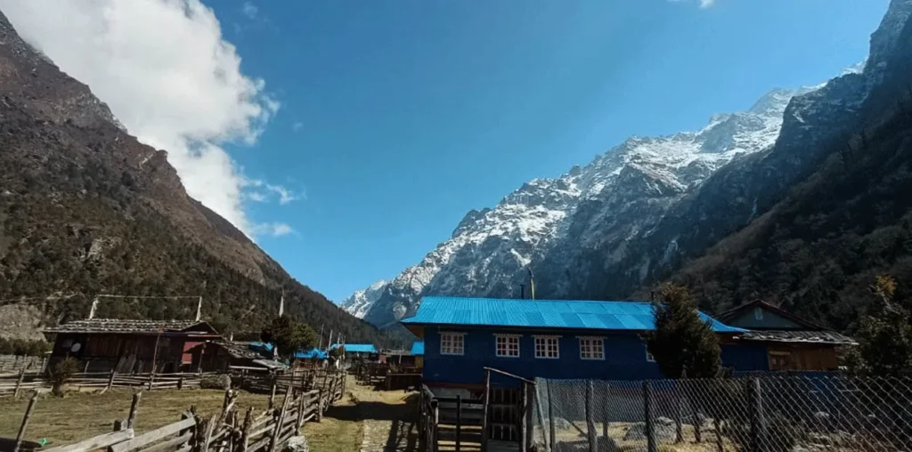
Today’s stretch is one of the more scenic low-altitude sections of the entire route. The valley opens up and the trail runs through open forest, past grazing meadows where yaks move slowly in the cold morning air, and alongside the Ghunsa Khola which has become noticeably cleaner and greener at this elevation. Ghunsa itself is the largest village on this part of the trek, with a small monastery, several tea houses that cater specifically to climbers heading toward Kanchenjunga, and a gompa whose interior walls are painted with vivid Buddhist murals in deep reds and blues. Spend the evening here slowly. The monastery is worth a respectful visit, and the monastery keeper will often share tea and a quiet conversation if you approach with patience.
Rest days at altitude are not lazy days. They’re the days that make your summit possible. This one is best spent on a short hike up to the ridgeline above Ghunsa, where the treeline ends and the high meadows begin. From the top of the ridge, you can see Jannu, the mountain also known as Khumbhakarna, a wall of black granite and ice that rises so vertically it seems almost impossible. It’s one of the most imposing views in the eastern Himalayas and rarely photographed because relatively few people make it this far. Back in the village by early afternoon, you can explore the monastery more thoroughly, write, rest, or simply observe village life, yaks being loaded, children playing in the courtyard, smoke curling from every chimney as the temperature drops toward evening.
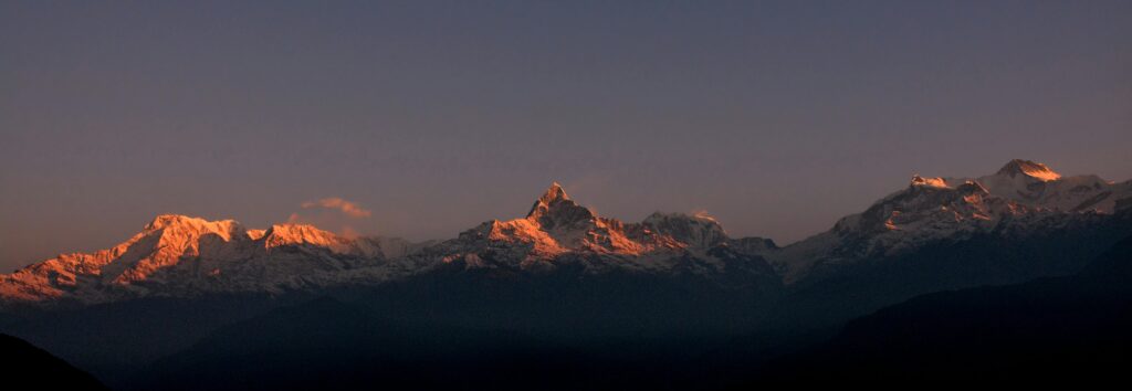
Above Ghunsa the vegetation pulls back quickly. Within an hour of leaving the village you’re moving through open, windswept terrain, low scrub, rocky moraines, and the first patches of permanent snow visible on the surrounding slopes. The Ghunsa Khola runs glacially clear here, its source now visible in the distance as a tongue of ice descending from the high peaks. Lhonak is a flat, open meadow used historically by yak herders as a seasonal grazing camp, and today it serves as an advanced base for climbers heading to Pangpema and the northern face of Kanchenjunga. The views from Lhonak at sunset, when Kanchenjunga catches the last pink light while everything below it goes dark, is one of those moments that requires no photograph to stay with you.
The walk to Pangpema follows the lateral moraine of the Kanchenjunga Glacier, a wide grey river of compressed ice and debris stretching several kilometers. The moraine is uneven underfoot, and you pick your way carefully along its spine, keeping the glacier to your left and the steep valley walls to your right. Pangpema opens suddenly from behind a ridge, a wide, flat basin sitting directly beneath the north face of Kanchenjunga at 8,586 meters. The scale here is difficult to process. The mountain rises nearly four vertical kilometers above where you’re standing, and the sounds, creaking ice, distant rockfall, wind, feel enormous. This is also where your high-camp plan for Bokta Peak comes fully into focus with your climbing guide.
From Pangpema, the route toward Bokta Peak peels away from the Kanchenjunga approach and heads across the glacier toward the peak’s southern shoulder. The terrain becomes more technical here, a mix of moraine walking, boulder fields, and the first stretches of snow travel requiring traction. Base camp sits in a protected hollow just below the main snow face, sheltered from the prevailing wind by a natural rock wall. Your Sherpa team will have the camp organized and warm by the time you arrive. The afternoon is spent gearing up, going over the summit plan, and resting. The sky at base camp at this altitude is a shade of blue that doesn’t exist at lower elevations, deep and saturated, and absolutely cloudless if the weather is holding.
High camp is established on a narrow snow platform above the glacier, with fixed ropes running up the steeper pitch above. You move in crampons from base camp, crossing the lower snowfield before ascending a 40-degree slope where the rope becomes your primary safety line. The work is slow and deliberate, and the thin air at this altitude means you’ll be breathing harder than the gradient alone would justify. High camp itself is minimal, two tents anchored against the slope, enough space to cook, sleep, and prepare for an early departure. The evening is still and cold. You eat, hydrate aggressively, check your gear one final time, and try to sleep before a 2 AM alarm that will feel like it comes immediately.
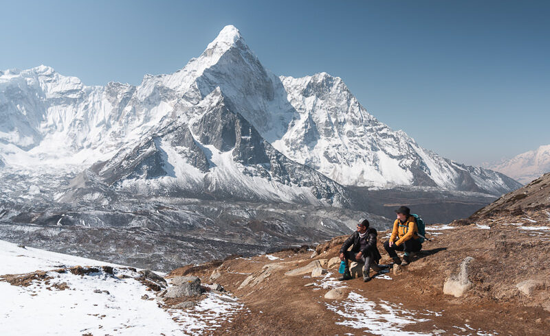
You leave high camp in darkness, headlamps cutting narrow beams into the black slope above. The first section is a steep snow face that requires careful front-pointing, and then the gradient eases onto a broad ridge where the full eastern Himalayan panorama begins to reveal itself as dawn breaks. Kanchenjunga dominates to the north, with Makalu, Lhotse, and on a clear day even Everest visible in the far distance. The summit of Bokta Peak at 6,143 meters is a snow crest, not a dramatic pinnacle, but the view from it earns every hour of the approach. Your guide will call the turnaround time based on conditions. The descent to base camp is careful and unhurried, and that evening at base camp feels like the best meal you’ve eaten in weeks regardless of what’s actually being served.
The body needs time after a summit push, and rushing the descent is where most expedition accidents happen. This rest day at base camp is deliberate and important. Muscles that worked at high altitude need recovery, and the psychological shift from summit focus to safe descent takes its own processing. Spend the morning writing, talking with your Sherpa team, or simply lying in the sun outside your tent watching spindrift stream off the upper ridges. By afternoon you begin breaking down camp and organizing loads for the descent. There’s a particular satisfaction in packing a camp after a successful summit, a sense of closure that feels different from any other kind of completion.
The descent back to Ghunsa is long but the legs are willing. Losing altitude has an almost immediate effect on energy levels and appetite, and by the time you’re back below 4,000 meters the heaviness in your head from the past few days begins to lift noticeably. The valley looks different coming down. Landmarks you registered on the way up reappear from new angles, and the familiarity is comforting. Ghunsa feels almost luxurious by comparison with what you’ve been sleeping in, a solid roof, a kitchen, the smell of something being cooked on a real stove. The village porter team will have carried loads ahead, and your bags will already be waiting. Celebrate modestly. There’s still several days of walking to go.
The return through the lower Ghunsa Valley has a different texture than the approach. You’re moving with the valley now instead of against it, and the pace is easier. The mani walls, the chortens, the monastery at Ghunsa visible behind you as you leave, these details accumulate differently when you know you won’t see them again on this trip. Gyabla in the late afternoon has warm tea and the cook preparing something generous for dinner. The bamboo forest below is visible from the lodge balcony, and the cloud that often fills the valley by 3 PM catches the evening light in layers. These lower rest days on a descent are often the ones people remember most fondly, because the pressure is gone and there’s nothing left to do but walk and look.
The descent continues through the increasingly lush and forested terrain of the mid-valley. The trees close back in, the sound of running water grows louder as you drop toward the river confluence, and the temperature climbs steadily. By the time you reach Sekathum you’re back in shirtsleeve weather, a transition that still feels surprising even when you were expecting it. The trail crosses and recrosses the river on the same log bridges you navigated on the way up, and the river itself looks different now, running higher after afternoon snowmelt on the peaks above. Sekathum’s small tea houses feel genuinely welcoming after high-altitude camping, and a hot meal here tastes like something earned.
The final day of actual trekking takes you back through the subtropical belt, past familiar suspension bridges, through the Rai and Limbu villages that bookended your journey into the mountains. The Tamur River is back, brown and powerful, and the warmth of the lowlands is unmistakable by midday. Taplejung feels like a town now rather than a remote outpost, and the sounds of motorbikes and music from small shops are startling after weeks in the upper valleys. Your team checks into the lodge, equipment is sorted and packed for transport, and the evening tends naturally toward storytelling. Everyone who has done a long expedition knows this feeling, the strange mix of relief, pride, and the quiet wish that it could have lasted a little longer.
The jeep retraces the mountain road south, and the journey that felt anticipatory on the way in now feels reflective. The Himalayas shrink in the rear window as you descend to the plains, and by the time you board the flight in Biratnagar the peaks are already a smudge of white on the northern horizon. Kathmandu receives you back with its usual noise and motion. Nepal Holiday Treks arranges a farewell dinner for the team, a chance to sit with your guides and Sherpas over good food and raise a glass to the mountain. The conversation will range from summit moments to the funniest camp incident anyone can recall, and someone will almost certainly start planning their next trip before dessert.
Your guide drops you at the airport with enough time for a calm goodbye. There’s no particular ceremony to the moment, just the particular clarity that comes after three weeks in the mountains. You leave Nepal with a summit certificate, a few thousand photographs that will never quite capture what the north face of Kanchenjunga looks like at sunrise, and a very specific knowledge of what your body can do at altitude. That knowledge is yours now. Bokta Peak gave it to you, and no algorithm was involved.
Includes/Excludes
Cost Includes
- Airport pickup & drop
- Professional climbing guide
- climbing permit
- Trekking permits
- Accommodation during the trek
- Tented camp at Base Camp
- All meals during the trek
- Climbing training
- Safety equipment
- First aid support
- Support staff
Cost Excludes
- International airfare
- Personal climbing gear
- Travel insurance
- Personal expenses
- Tips for guide & porter
- Extra accommodation
- Emergency rescue
FAQs
Bokta Peak sits in the moderate-to-challenging range. The trek to base camp is long and involves several days at high altitude before you even touch technical terrain. The summit push requires crampons, an ice axe, and the ability to move safely on snow slopes. It’s not a technical peak in the Himalayan mountaineering sense, but it’s significantly more demanding than a standard trekking route. Prior high-altitude trekking experience, ideally above 5,000m, is strongly recommended.
Spring (late March to May) and autumn (October to November) are the two reliable windows. Spring brings clearer skies and warmer temperatures at base camp, while autumn offers sharper visibility after the monsoon clears. Winter is bitterly cold at these elevations, and the monsoon season makes the trails slippery and the mountain unpredictable. Most climbers prefer spring for the added benefit of the rhododendron bloom on the lower approach.
Yes. Bokta Peak requires a Nepal Mountaineering Association (NMA) trekking peak permit, along with a Kanchenjunga Conservation Area permit and a restricted area permit, since this part of eastern Nepal requires additional authorisation. Your outfitter handles all permit logistics, but it’s worth knowing these are mandatory and non-negotiable. Attempting the route without proper permits is both illegal and risky from a rescue and insurance standpoint.
You’ll need a four-season sleeping bag, insulated mountaineering boots compatible with crampons, a harness, helmet, ice axe, and trekking poles. A layering system that handles everything from subtropical forest heat to subzero summit conditions is essential. The agency provides fixed ropes and group climbing equipment, but personal gear is your responsibility. A detailed gear list will be shared after booking so you have time to source or rent what you need.
Honestly, no. Bokta Peak is not a beginner’s first peak. You should have prior high-altitude trekking experience, some familiarity with glacier travel, and good physical conditioning before considering this climb. If you’re new to altitude or technical terrain, a smaller peak like Island Peak or Mera Peak would be a smarter starting point. Once you have those under your belt, Bokta Peak becomes a natural and very exciting next step.