Trip Info
- Tea House & Tented Camp
- Included (Guide & Staff)
- Trekking & Climbing Permits Included
- 6,135m
- Kathmandu
- Spring & Autumn
- Kathmandu
- Professional Climbing Guide
- Airport Pickup & Drop Included
- 30 Days Before Start
Lobuche West Peak Climbing
Lobuche West (6,135m) is one of the most rewarding trekking peaks in the Khumbu region, sitting just above the famous Lobuche village with a summit that looks directly across at Everest, Nuptse, Makalu, and Cho Oyu. This 16-day expedition takes you through the heart of the Sagarmatha National Park, past mani stone walls and monastery trails, and up into a world of glacial ice and hard-packed snowfields. It is a serious undertaking, but one that is well within reach for trekkers with solid fitness and a genuine appetite for high-altitude adventure.
The route follows the classic Everest Base Camp trail as far as Lobuche village before turning toward the mountain itself. You gain altitude steadily, sleep at key staging points, and build real confidence in your body and gear before attempting the summit push. The climbing sections involve fixed ropes, crampons, and ice axe use, so you are not simply hiking to the top, you are doing actual mountaineering on a proper glaciated peak.
What makes this trip stand out is the combination of cultural immersion and technical climbing. You walk through Sherpa villages, visit centuries-old gompas, and share tea houses with other climbers and trekkers before stepping onto a route that very few people in the world ever attempt. Nepal Holiday Treks designs this itinerary with thoughtful acclimatization and experienced high-altitude guides to give you the best possible chance at the summit.
Highlights
- Everest, Nuptse, Makalu, and Cho Oyu
- Scenic Everest region trekking
- Acclimatization at Namche & Dingboche
- Climbing training included
- Experience Sherpa culture
- Explore Tengboche Monastery
- Glacier travel & rope climbing experience
Itinerary
This 18-day itinerary is carefully designed to ensure safe acclimatisation and a successful summit experience. The journey begins in Kathmandu and follows the classic Everest trekking route through Namche Bazaar, Tengboche, and Dingboche before reaching Lobuche West Base Camp.
You land at Tribhuvan International Airport and step into the organized chaos that is Kathmandu. After your transfer to the hotel in Thamel, the afternoon is yours to wander through incense-thick alleyways, pick up any last gear from the climbing shops on Tridevi Marg, or simply recover from the flight over tea and dal bhat. Your guide will meet you in the evening for a thorough briefing covering the route, gear list, permit requirements, and daily expectations for the days ahead. This is also the time to voice any concerns, get a feel for who you are climbing with, and confirm that all your equipment is ready for the mountains. The meeting is informal but important, and it sets the tone for the entire expedition. Kathmandu is overwhelming at first, but it is also the perfect gateway into what lies ahead.
The flight to Lukla is one of the most exhilarating 35 minutes in aviation. The Tenzing-Hillary Airport sits on a sloped runway carved into the side of a ridge, and the moment the plane lands and you step out, the smell of pine and cold mountain air tells you clearly that you have arrived somewhere different. From Lukla, the trail drops gently through rhododendron and pine forest, crossing suspension bridges over the fast-moving Dudh Koshi River before reaching the quiet settlement of Phakding. The path is relatively easy on this first day, which is intentional since your legs and lungs need time to register the change in environment. You pass through small villages where locals carry improbable loads on traditional dokos, and prayer flags snap overhead at every ridge crossing. Phakding itself is a compact, friendly place with a handful of teahouses and clear river views.
This is the day most trekkers remember as their first real test. The trail climbs through several river crossings and dense forest before reaching the Hillary Suspension Bridge, which sways nearly 70 meters above the Dudh Koshi gorge and demands full attention and steady nerves. Beyond the bridge, the path tilts sharply upward through a zigzag ascent that seems to go on longer than it should, but the reward at the top is your first unobstructed view of Everest, framed perfectly between the ridgelines. Namche Bazaar appears suddenly as you crest a final ridge, a crescent-shaped bowl of colorful buildings terraced into the hillside at the confluence of trade routes. The town has a proper bakery, a Saturday market, an outdoor gear shop or two, and a buzz that comes from being the social hub of the entire Khumbu valley. You settle into your lodge, drink something warm, and let your body start the work of adjusting to the thinner air.
Staying in Namche today is not about resting, it is about going higher during the day and returning lower to sleep, which is how acclimatization actually works at altitude. The hike up to the Everest View Hotel at Syangboche gives you a clear sightline to Everest, Lhotse, Ama Dablam, and Thamserku all at once, a panorama that no photograph quite captures accurately. The trail also takes you past the Sagarmatha National Park headquarters, where the small museum explains the geology, ecology, and climbing history of the region in plain, readable detail. You may also hike further toward Khumjung village, where the famous Yeti scalp is displayed in the monastery and where Sir Edmund Hillary built one of the first schools in the region. The descent back to Namche is easy and quick, and by the time you reach your teahouse the altitude gain has already done its quiet work on your red blood cell count. Use the afternoon to check and recheck your gear, since fixing problems in Namche is far easier than fixing them at 5,000 meters.
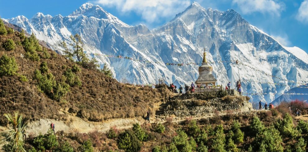
The trail out of Namche follows a high contour route with Ama Dablam’s south face hanging directly ahead for much of the morning. You cross into progressively more open terrain, passing through Sanasa junction and then descending briefly to the Dudh Koshi crossing before a sustained climb through juniper and rhododendron forest brings you to Tengboche. The Tengboche Monastery is the largest in the Khumbu region, a serious Buddhist institution with practicing monks and daily puja rituals that you are welcome to observe respectfully from the back. The monastery courtyard, with its prayer wheels and stone-carved mani walls, sits at one of the finest viewpoints on the entire trek, with Everest, Nuptse, Lhotse, and Ama Dablam arranged in a semicircle above the treeline. The village itself is small, a cluster of teahouses gathered around the monastery, and the air is noticeably thinner and sharper than Namche. Evenings here are quiet and cold, which makes the morning views even more striking when you step outside before breakfast.
Leaving Tengboche, the trail descends through the last significant tree cover you will see for the next week. The forest thins quickly as you pass through Pangboche, one of the oldest Sherpa villages in the Khumbu, where a small monastery contains what locals say are the actual bones of a Yeti hand. Beyond Pangboche the landscape opens into wide, rocky moraine valleys with stone-walled potato fields and yak pastures that feel genuinely remote. You cross the Imja Khola river and begin a gradual climb toward Dingboche, arriving in a broad, flat valley encircled by massive peaks including Lhotse Shar, Island Peak, and the Amphu Laptsa ridge. Dingboche is a proper mountain village with a clear seasonal rhythm, its teahouses open and lively in trekking season and shuttered under deep snow in winter. The altitude steps up meaningfully here, so you will likely notice the effects at bedtime, with vivid dreams and slightly labored breathing being entirely normal signs of your body adjusting.
Today’s hike climbs to the top of Nagarjun Hill, a rounded ridge above Dingboche that serves as one of the best acclimatization viewpoints in the entire Khumbu. The ascent is steep from the start, gaining several hundred meters of vertical over loose rocky terrain, and by the time you reach the summit cairn you are looking directly at Makalu’s east face, the full length of the Imja valley, and the high ridgeline connecting Lhotse to Island Peak. This hike has a purpose beyond scenery, it pushes your cardiovascular system to work harder at altitude while letting you sleep lower, the most effective acclimatization strategy available without supplemental oxygen. The descent back to Dingboche is fast, leaving most of the afternoon free for equipment checks, rope and crampon practice if your guide recommends it, and reading or rest. Many climbers on this route use this quiet afternoon to mentally walk through the summit approach, reviewing maps and photos of the route above Lobuche.
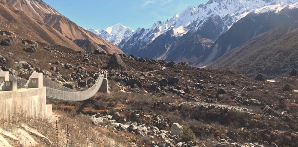
The trail from Dingboche to Lobuche is one of the most visually striking sections of any trek in Nepal. You climb steadily out of the Dingboche valley, cross the Thukla pass area through a field of memorial chortens built in honor of climbers who died on Everest and nearby peaks, and enter the upper Khumbu moraine. The memorials are sobering and worth pausing at, they remind you very directly what kind of environment you are entering and why preparation matters. Above Thukla the valley narrows and the Khumbu Glacier becomes a constant presence on your left, its grey and brown surface broken by ice towers and meltwater streams. Lobuche itself is a windswept cluster of lodges pressed against the moraine, with almost no vegetation and a cold that arrives well before sunset. From the village, your first real views of Lobuche West’s western ridge appear, giving you a chance to identify the route with your guide before tomorrow’s approach. It is a good evening for an early dinner, equipment organization, and sleep.
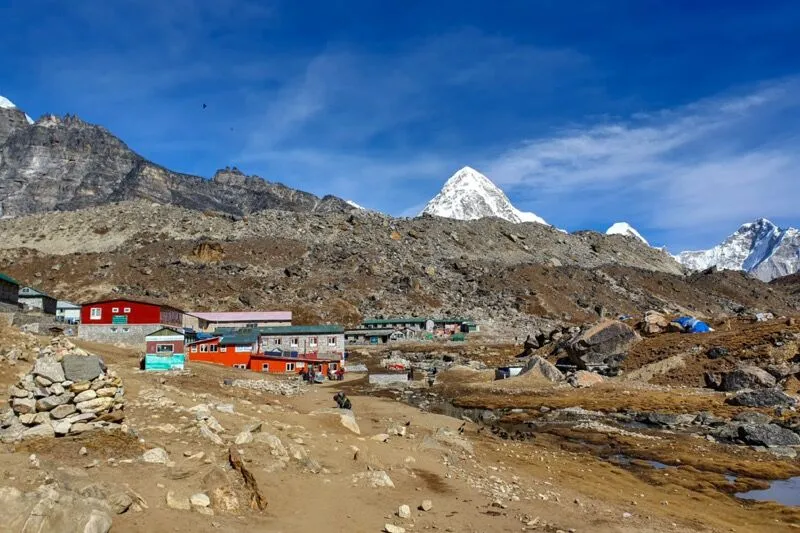
Before committing fully to the climb, today takes you to Gorak Shep and then on to Everest Base Camp. The path across the Khumbu Glacier moraine to Gorak Shep is rough and exposed, crossing a high, flat lakebed that freezes solid overnight and thaws slowly through the morning. Gorak Shep is the last settlement before EBC, a handful of lodges clinging to the edge of the glacier with no trees, no warmth, and extraordinary views in every direction. From Gorak Shep the trail to Everest Base Camp follows the lateral moraine of the Khumbu Glacier, weaving between house-sized ice towers and the colorful tents of expedition teams preparing for their Everest attempts. Base Camp itself is not a dramatic summit, it is a working camp at the foot of the Khumbu Icefall, but standing there among the expedition flags and listening to the glacier groan is an experience that stays with you. You return to Lobuche in the late afternoon, slightly tired but adjusted and mentally focused for the days ahead.
This day is about transition rather than distance. You move your climbing gear, sleeping equipment, and supplies from Lobuche to the base camp area for Lobuche West, situated on the moraine just below the glacier approach. The carry is not technically demanding, but it is physically tiring at altitude with a full pack, and it gives you important mental preparation for what the mountain looks like up close. Your guide will spend time reviewing crampon fitting, ice axe arrest technique, and fixed rope protocol, whether you are new to these skills or simply need a refresher in cold conditions. You also study the route above you, tracing the line from the glacier to the west ridge and identifying the high camp location. The afternoon is quiet, the mountain environment absorbing and calm, with wind and light shifting constantly across the ice faces above. An early sleep at high altitude is difficult for most people, but making the attempt is still worthwhile.
The climb from base camp to high camp crosses the lower Lobuche Glacier and ascends a steep snow and ice slope to a sheltered camp below the west ridge. You rope up on the glacier, moving carefully across crevassed terrain before gaining the steeper ground above. Fixed ropes are typically already in place on the steeper sections, and your guide leads the way, setting a pace that is deliberately slow and deliberate because efficiency at this altitude matters more than speed. High camp is a narrow, windy platform with tents staked firmly against the gusts that channel along the ridge. Once camp is established, you eat what you can manage, drink plenty of water, and organize everything you will need for the pre-dawn start tomorrow. The views from high camp across to Nuptse’s south face and down the full length of the Khumbu valley are extraordinary, and worth stepping outside your tent to appreciate before the temperature drops completely.
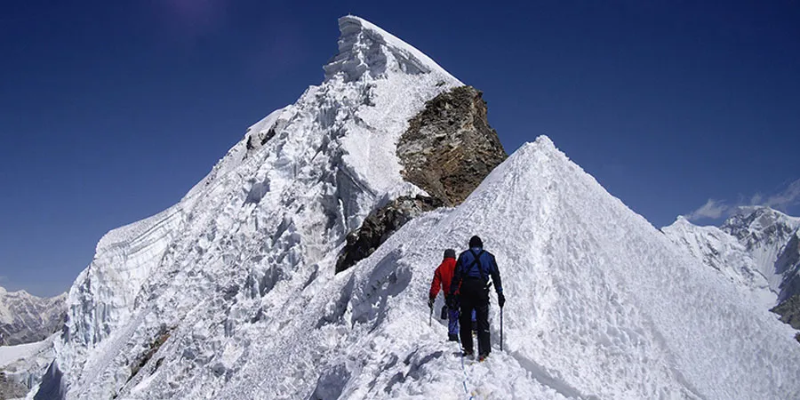
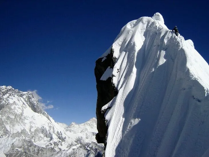
The alarm sounds between midnight and 2:00 AM. By headlamp, you check your harness, layer up, and begin the final push to the summit. The route from high camp follows the west ridge on mixed snow and rock, with sections of 45- to 55-degree ice requiring precise crampon technique and confident movement on the fixed lines. The summit ridge is narrow and exposed, and in the pre-dawn darkness the world below you disappears entirely, leaving only the beam of your headlamp and the sound of crampons on hard snow. Reaching the summit at first light is genuinely moving. Everest’s black pyramid rises directly northeast, Makalu fills the eastern horizon, and to the south the entire Khumbu valley stretches out below the clouds. You spend a short time at the top, photograph the moment, and begin a careful descent back to high camp and then all the way down to Lobuche. The descent feels faster and the relief is real.
After the summit and a full descent, Lobuche feels extraordinarily comfortable. But the body recovers faster when it moves to lower altitude, so today you continue down the valley to Pheriche, a village that sits slightly lower and wider than Dingboche, in a broad moraine bowl with a Himalayan Rescue Association post and a small medical clinic. The trail is familiar by now, retracing ground you covered earlier in the trip, but the views look different on the way down, colors richer, distances shorter, the mountains more relaxed somehow. Pheriche is quieter than Namche or Dingboche, preferred by climbers who want a simple night without too much teahouse noise. Your legs are tired in a satisfying way, and the appetite that altitude sometimes suppresses tends to return sharply around this elevation. It is a good evening for reflection on what you have just done.
The long descent back to Namche covers ground quickly. You pass back through Pangboche and Tengboche, the forest thickening around you as altitude drops, and by Kyangjuma the rhododendrons are back and the air noticeably warmer. Namche arrives in the late afternoon, and the town that felt demanding on the way up now feels positively urban. You can find a proper espresso, a bakery with apple pie, a hot shower in most lodges, and reliable phone signal for the first time in days. Nepal Holiday Treks recommends using this evening to check in with family, review the trip, and allow the team to debrief informally over dinner. The contrast between Namche and where you stood 48 hours ago is almost impossible to process in a single evening.
The final day of trekking is mostly downhill, retracing the river valley all the way back to Lukla. The trail is well-worn and fast, the body moving freely at lower altitude with lungs that feel almost luxuriously efficient after two weeks above 4,000 meters. You cross the Hillary Bridge again, pass through Phakding, and arrive in Lukla with time to spare before dark. The town around the airstrip is lively in the way that final days always are, groups celebrating completions, porters settling accounts, and teahouse owners preparing for the next wave of trekkers arriving in the morning. Your team dinner in Lukla is a proper celebration. Certificates, toasts, and stories from the summit tend to flow until well past a reasonable bedtime.
The flight back is weather-dependent, and Lukla mornings can be clear and sunny or completely socked in with no warning. Assuming good conditions, the 35-minute flight delivers you back into Kathmandu by mid-morning, leaving most of the day open. Some people use this time for last-minute shopping in Thamel, others visit Boudhanath Stupa or Pashupatinath Temple before their onward flight. Your guide will arrange the airport transfer for your international departure, or help with hotel extension if you want an extra night in the city. The journey from a bustling Himalayan capital to a 6,135-meter summit and back again takes just 16 days, which somehow seems both too long and not nearly long enough.
Includes
Cost Includes
- Airport pickup & drop
- Lukla flight (round trip)
- Professional climbing guide
- Lobuche East climbing permit
- Sagarmatha National Park permit
- Accommodation during trek
- Tented camp at Base Camp
- All meals during trek
- Climbing training
- Safety equipment
- First aid support
- Support staff
Cost Excludes
- International airfare
- Personal climbing gear
- Travel insurance
- Personal expenses
- Tips for guide & porter
- Extra accommodation
- Emergency rescue
FAQs
Yes, prior experience with crampons, ice axes, and fixed ropes is strongly recommended. Some technical trekking experience at altitude will significantly improve both your safety and your enjoyment of the climb.
The best windows are pre-monsoon (March to May) and post-monsoon (late September to November). October and November offer the most stable weather with clear skies and firm snow conditions on the upper mountain.
You should be able to trek 6 to 8 hours a day with a daypack for multiple consecutive days, and have a base fitness level built from regular cardio training over at least three months. The climbing sections demand more than trekking fitness, especially on summit day.
You will need personal items like mountaineering boots, crampons, ice axe, harness, and helmet. Nepal Holiday Treks provides ropes, high camp tents, and group climbing hardware, while personal gear is your own responsibility to bring or rent in Kathmandu.
Yes, it is a genuine consideration above 4,000 meters, which is why the itinerary builds in acclimatization days and gradual altitude gain. Recognizing early symptoms and descending promptly if they worsen is the most important safety practice on any high-altitude expedition.